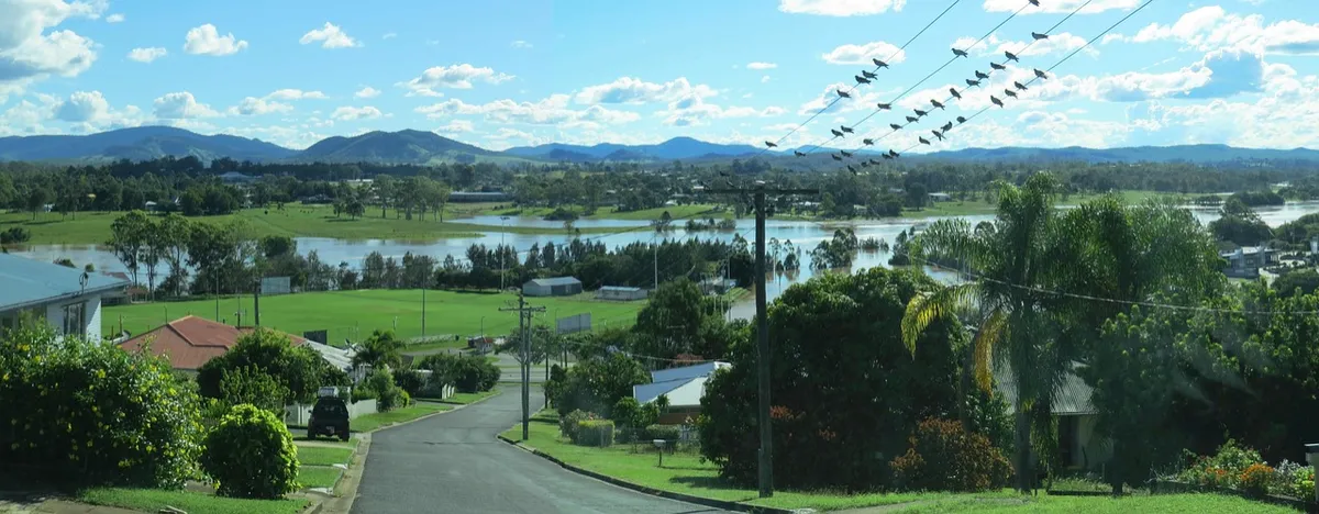
Floodplains and FEMA Maps in Mecklenburg
By the Tide & Timber Investments team, a veteran-owned residential developer in Charlotte, North Carolina, and an affiliate of Tide & Timber Ventures, LLC. Last updated 21 October 2026.
Quick answer: Mecklenburg County has two mapped floodplains: the FEMA floodplain and a community floodplain based on future land-use conditions, which includes the FEMA floodplain. In Charlotte, any development in the community floodplain needs a floodplain development permit, new homes must have their lowest floor at or above a set flood protection elevation, and building in the innermost encroachment area is tightly restricted. Check any lot free on Polaris or the county’s floodzone tools, then confirm with Charlotte-Mecklenburg Storm Water Services.
Information current as of 21 October 2026, 9:57 PM ET. Rules, fees, maps and market figures change. Anything we could not confirm from an official source has been left out of this article. Check the linked official sources before relying on any detail.
After the trees in Trees and the Charlotte Tree Ordinance, we turn to the water: the floodplain lines that can change what a lot is worth.
Floodplain catches more Charlotte lots than almost any other check. It’s also one of the easiest to start on, because the maps are public and free.
This article explains what the lines on Mecklenburg’s flood maps mean, what you can and can’t build inside them, and how they change the numbers on a project. The rules summarised here come from Article 27 of the City of Charlotte’s Unified Development Ordinance (UDO), as of 21 October 2026. Maps and rules change, so always check the current versions. Outside Charlotte and its extraterritorial jurisdiction, ask Storm Water Services which ordinance applies.
Why does Mecklenburg have two floodplains?
Floodplain | What the UDO says about it |
|---|---|
FEMA floodplain (FEMA special flood hazard area) | The floodplain shown on FEMA's flood insurance rate maps (FIRMs). See it on the FEMA Flood Map Service Center |
Community floodplain (community special flood hazard area) | Land with a 1% or greater yearly chance of flooding from a "community base flood", which is determined using future land-use conditions. Mapped by Charlotte-Mecklenburg Storm Water Services |
The community floodplain includes the whole FEMA floodplain plus an extra outer band, the community flood fringe. Because it plans for future land use, the local map can reach further than FEMA’s.
In plain words: FEMA's map shows where a big flood can reach today. Mecklenburg's map also plans for more rain running off as more land gets paved and built on, so it usually covers more ground.
As of 21 October 2026, floodplains are mapped for every stream in the county draining one square mile or more. Smaller creeks may have no mapped floodplain at all, but they can still flood and can still carry stream buffers.
As of 21 October 2026, the maps rely on the flood insurance study for Mecklenburg County and the City of Charlotte dated 16 November 2018, plus later approved revisions. Where preliminary maps show higher community flood levels, the UDO uses the higher ones for local rules.
What are the zones inside the floodplain?
Think of the land beside a creek as four strips, from the water outward:
FEMA floodway. The creek and the land right next to it, where flood water moves fastest. Building here is almost never allowed.
Community encroachment area. The next strip out. It's kept open so flood water has room to pass. Building here is very hard.
FEMA flood fringe. The rest of the area FEMA says floods. Water reaches it in a big flood, but it's usually slower and shallower. You can build if the house is raised.
Community flood fringe. The outer strip Mecklenburg adds for future runoff. Same as number 3: build only if the house is raised.
What does "flood fringe" mean? It's the edge of the flood zone: land that gets wet in a big flood, but away from the fast-moving water near the creek.
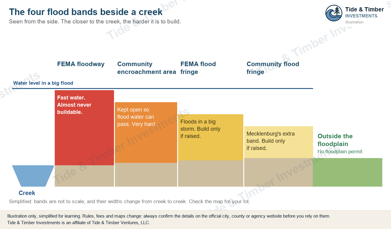
The closer to the stream, the stricter the rules.
What can you build in a Mecklenburg floodplain?
As of 21 October 2026, under the UDO:
Area | New homes and fill |
|---|---|
FEMA floodway | Only with a professional engineer’s study showing no rise (0.00 feet) in FEMA flood levels, or a FEMA map revision process |
Community encroachment area | Only with an engineer’s study showing no more than a 0.10-foot rise, or a local map revision process |
Flood fringe areas | Possible with a floodplain development permit, if the home’s lowest floor is at or above the flood protection elevation |
Outside the floodplain | No floodplain permit, but stormwater, buffers and drainage rules still apply |
In practice, a typical infill buyer should treat the floodway and the encroachment area as places a house won’t go. The engineering, map revisions and timelines rarely make sense for one or two homes.
What is the flood protection elevation?
Inside the floodplain, new homes and substantial improvements must have their lowest floor at or above the flood protection elevation (FPE).
As of 21 October 2026, the UDO sets the FPE at the community base flood elevation plus two feet of extra height (called freeboard). The UDO says this becomes one foot once new future-conditions maps are issued. Along the Catawba River, Lake Wylie and Mountain Island Lake, it’s the FEMA base flood elevation plus two feet.
Raising a house costs money: a taller foundation, more steps to the front door, sometimes a different design. Equipment such as HVAC units, water heaters and electric panels must also be protected up to the FPE. And if the house or its driveway sits in the floodplain, the UDO generally requires dryland access: a route to the street that stays above flood level.
Do I need a floodplain permit?
Yes, for any development in the community floodplain. There are two types:
General floodplain development permit (GFDP). For low-impact activities such as landscaping, fences that don’t block flow, and utility poles, as long as they cause no measurable rise in flood levels.
Individual floodplain development permit (IFDP). For bigger work, including new homes and fill.
Before the certificate of occupancy, expect to provide a final as-built elevation certificate confirming the floor heights. Work near the encroachment area may also need a surveyor’s or engineer’s certification that no fill went where it shouldn’t.
What about older homes and teardowns?
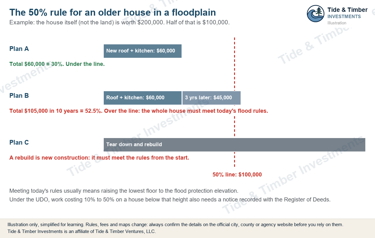
If an existing house sits in the floodplain, renovating it can trigger the full rules. Under the UDO, a substantial improvement is work costing 50% or more of the structure’s market value, counted over a ten-year period. Cross that line and the whole building must generally meet today’s floodplain standards. A teardown and rebuild is new construction, so it must comply from the start.
An example. Say the house itself (not the land) is worth $200,000. Half of that is $100,000.
A new roof and kitchen for $60,000 is 30%. That's under the line.
The same $60,000 now, plus a $45,000 addition three years later, adds up to $105,000 within ten years. That's 52.5%, so the whole house must be brought up to today's floodplain rules, which usually means raising the lowest floor.
Tearing it down and rebuilding counts as new construction from day one.
One more step to know: under the UDO, work costing 10% to 50% of the value on a house whose lowest floor sits below the flood protection elevation needs a notice of floodplain improvements recorded with the Mecklenburg County Register of Deeds before the building permit.
Where can I check a Mecklenburg floodplain map for free?
Charlotte Storm Water Services lists these tools (as of 21 October 2026):
Polaris 3G, the county property map, with floodplain layers for any parcel.
3D Interactive Floodzone Mapping, a county floodzone viewer.
Draft and Preliminary Flood Map Review, for proposed map changes.
Mecklenburg County Open Mapping, with downloadable FEMA floodplain, community floodplain, FEMA floodway and community floodway (the encroachment area) layers.
FEMA's own Flood Map Service Center is another place to look. Treat online maps as your first filter. A survey that plots the flood lines and ground elevations on the lot is what an engineer and the permit office will rely on.
How to check a lot on Polaris, step by step
Here's the whole check, using Freedom Park (a public park on Little Sugar Creek) as the example.
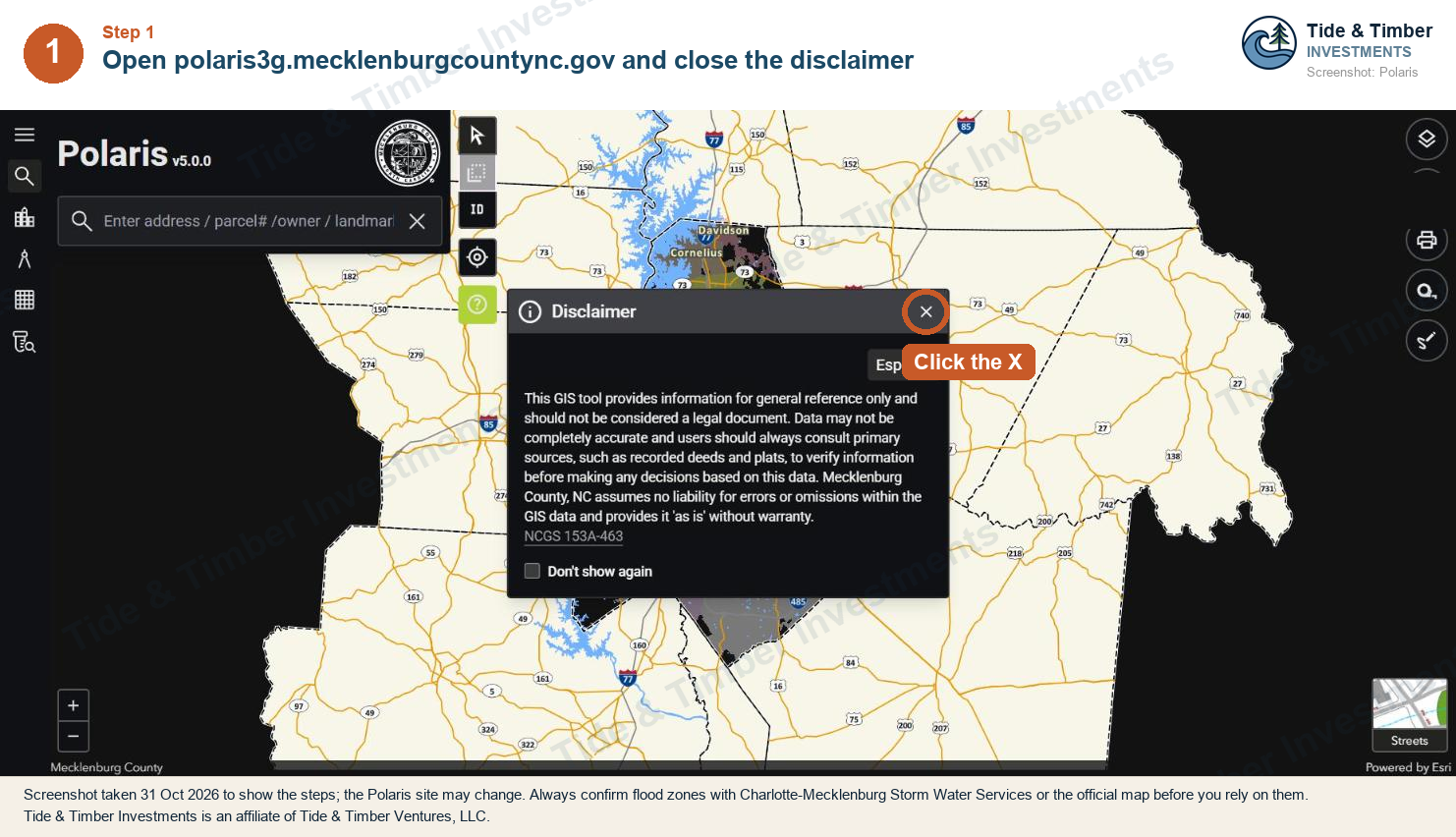
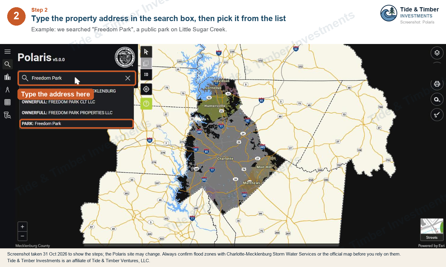
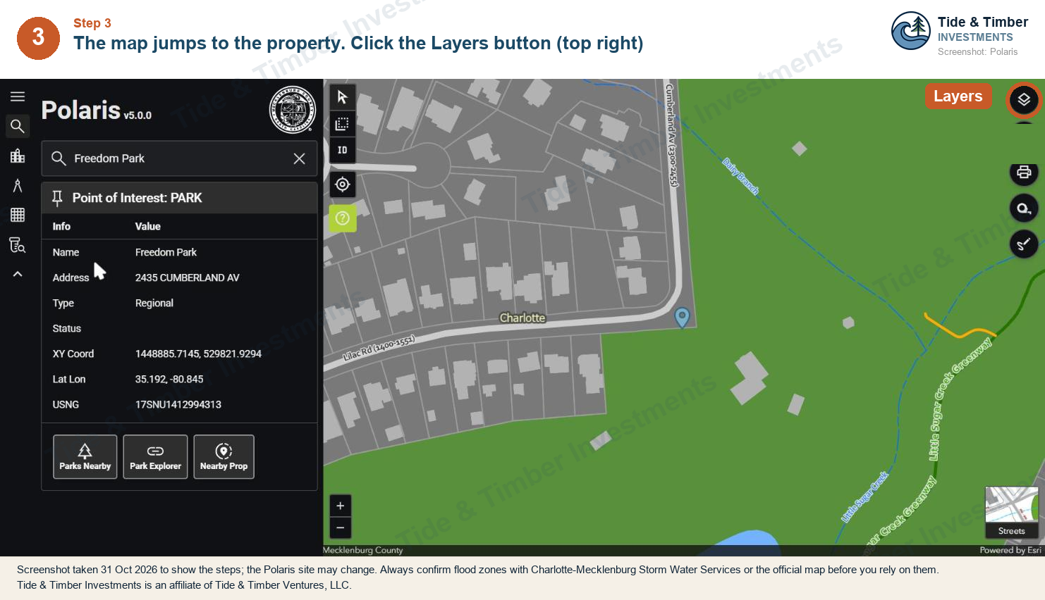
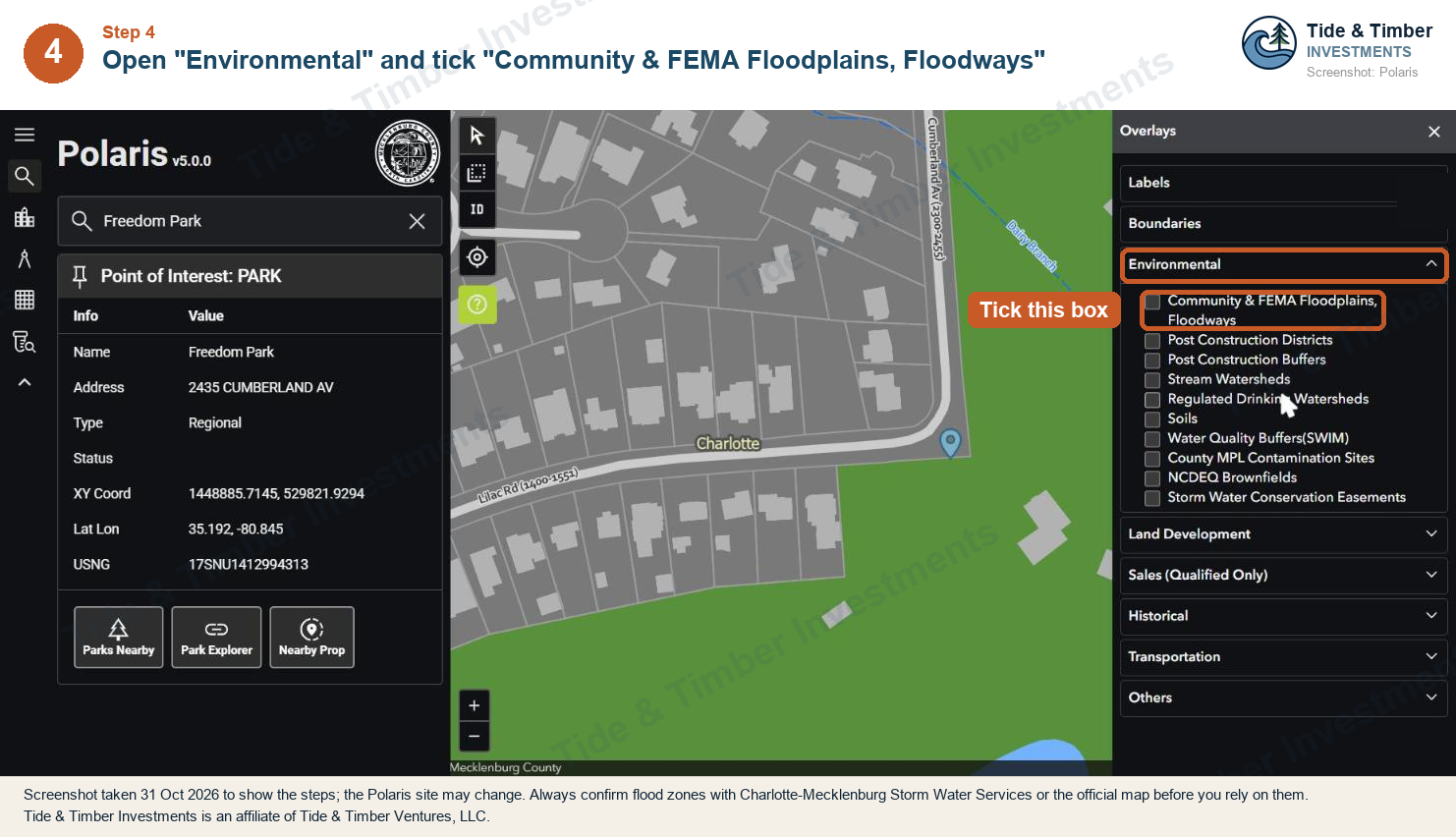
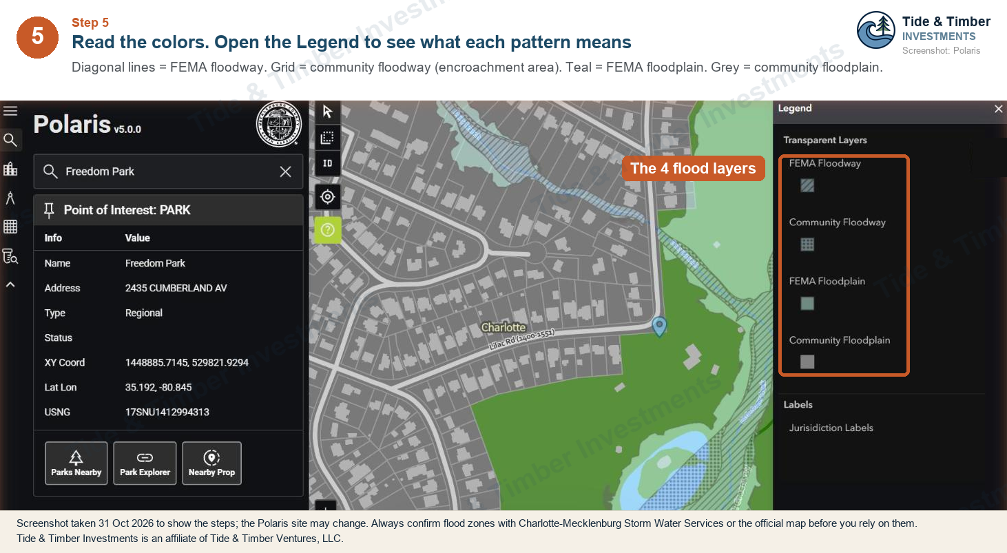
If any of the four patterns touches the lot, look closer: plot the lines on a survey and call Storm Water Services before you rely on it.
What about lots outside Mecklenburg?
The rules in this article are Charlotte and Mecklenburg rules. Other counties and towns have their own floodplain rules, but you can check any lot's flood zone for free:
Any North Carolina county: the state's Flood Risk Information System (FRIS). Type an address to see its official flood zone.
Any South Carolina county: the SC Department of Natural Resources Floodplain Map Viewer.
Anywhere in the US: FEMA's search by address.
Each county's own map also has a flood layer:
County | County map with a flood layer | Official statewide map |
|---|---|---|
Union, NC | UC Atlas (its flood layer uses 2014 map lines) | |
Iredell, NC | ||
Cabarrus, NC | ||
Gaston, NC | ||
Lincoln, NC | Lincoln County parcel viewer (turn on "FEMA Flood Zones") | |
York, SC | York County One Map Reports ("Floodzones" report) | |
Greenville, SC |
County maps can lag behind the newest flood lines. For the official zone, use the statewide map or FEMA, then call the county or town's floodplain office.
How a floodplain changes the numbers
What you find | What it can mean |
|---|---|
Line through the back yard only | Often little, but plot it on the survey |
Flood fringe in the building area | Raised foundation, permits, elevation certificates, dryland access |
Encroachment area or floodway in the building area | Usually the end of the deal for a small project |
Stream with a SWIM buffer | Lost usable land; no structures or fill in the buffer unless exempted |
Insurance matters for the exit, too. Before you buy, ask a lender and an insurance agent whether flood insurance would be needed on the finished home and roughly what it would cost. That can affect who can afford to buy it. (See SWIM Buffers in Mecklenburg County (coming soon) and Floodplain Development Permits (coming soon).)
Keep reading: If the land checks out, the next question is what it costs to build. What Goes Into Charlotte Build Costs per Square Foot.
Frequently asked questions
How do I know if my property is in a floodplain in Mecklenburg County?
Look up the parcel on Polaris and turn on the floodplain layers (see the step-by-step pictures above), or use the county's 3D Interactive Floodzone Mapping tool. You can also check FEMA's Flood Map Service Center. Confirm with Charlotte-Mecklenburg Storm Water Services before you rely on it.
What is the difference between the FEMA floodplain and the community floodplain?
The FEMA floodplain is the one on FEMA’s flood insurance rate maps. Mecklenburg’s community floodplain is based on future land-use conditions and includes the FEMA floodplain plus an outer community flood fringe. In Charlotte, a floodplain development permit is needed for development anywhere in the community floodplain.
Can you build a house in a floodplain in Charlotte?
In the flood fringe, often yes, with a floodplain development permit and the lowest floor at or above the flood protection elevation. In the FEMA floodway or community encroachment area, new homes need engineering studies showing almost no rise in flood levels, which is rarely practical for a single lot.
How high does a new house have to be in a Mecklenburg floodplain?
As of 21 October 2026, Charlotte’s UDO requires the lowest floor to be at or above the community base flood elevation plus two feet. Along the Catawba River, Lake Wylie and Mountain Island Lake, the standard is the FEMA base flood elevation plus two feet. Check the current rules for your lot.
Do I need flood insurance on a new build in Charlotte?
It depends on the property, the flood zone and the buyer’s lender. Ask a lender and an insurance agent about the specific address before you commit, and check FEMA’s flood maps.
Sources
Checked 21 October 2026 at 9:57 PM ET.
City of Charlotte UDO, Article 27, Floodplain Regulations: charlotteudo.org
City of Charlotte UDO, Article 26, SWIM Buffers: charlotteudo.org
Charlotte Storm Water Services, data and apps (floodzone tools, map review, open data): charlottenc.gov
Mecklenburg County 3D Interactive Floodzone Mapping: gis.mecklenburgcountync.gov/3dfz
Mecklenburg County Draft and Preliminary Flood Map Review: gis.mecklenburgcountync.gov/fmr
Mecklenburg County Polaris property map: polaris3g.mecklenburgcountync.gov
FEMA Flood Map Service Center: msc.fema.gov
Want to go deeper?
This article is part of our Due Diligence series. The companion webinar, A Deal That Dies in Diligence Is Cheap, walks through floodplain and the other checks that decide whether a lot is worth buying.
Join the waitlist for this webinar →
Related reading:
Stormwater Rules for Small Infill Projects (coming soon)
Start Here: A Plain-English Guide to Real Estate Investing in Charlotte
This article is for general education only. It isn’t legal, tax or investment advice, and it isn’t an offer to sell or a solicitation of an offer to buy any security. Any offering by Tide & Timber Investments is made only to persons with whom we have a pre-existing relationship, through formal offering documents. Real estate investing involves risk, including loss of principal. Rules, fees and market conditions change; confirm details with the relevant county, city or town and with your own financial, tax and legal advisers before you act.

